Explore downloadable examples demonstrating WinLoG capabilities for geotechnical, geological, environmental, hydrogeological, mining, and specialty investigations. Selected examples include PDF logs, XML templates, XML borehole data, and related Knowledge Center articles.
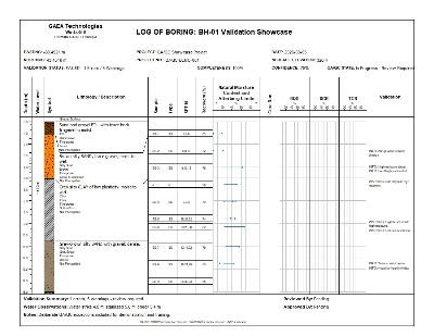
A comprehensive demonstration of intelligent borehole validation.
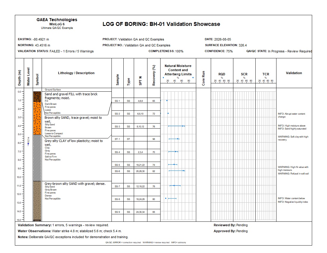
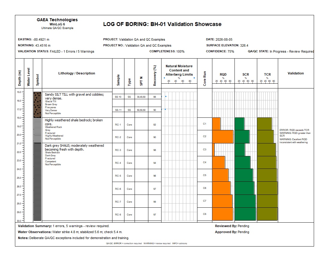
This example intentionally contains realistic data-quality issues so the WinLoG validation engine can demonstrate automated domain checks, cross-dataset consistency checks, groundwater validation, SPT QA/QC, Atterberg Limit checks, and rock-core validation.
See the complete showcase, preview both log pages, review the capabilities demonstrated, and access related Knowledge Center resources.
Explore This ExampleThese examples demonstrate how WinLoG applies automated validation rules to borehole, sample, laboratory, groundwater, mineral exploration, oil and gas exploration, assay, rock-core, pavement, and subgrade data. The flagship showcase provides broad coverage, while focused examples demonstrate specific workflows. They are designed to show not only how a professional log looks, but how WinLoG identifies inconsistent, incomplete, or physically questionable data before a record is finalized.
The flagship QA/QC example combines soil, SPT, laboratory, groundwater, and rock-core data in a single borehole. Deliberate errors and warnings demonstrate automated domain checks and cross-dataset consistency validation.
Demonstrates: SPT, Water Content, Atterberg Limits, USCS, Groundwater, Core Run, RQD, SCR, TCR, Validation Results, Completeness and Confidence.
A focused geotechnical validation example using BH-02 GEO-QAQC. It demonstrates automated QA/QC for conventional soil-boring data without the rock-core datasets used in the flagship showcase.
Demonstrates: SPT N-values, sample recovery, USCS classification, groundwater, Water Content and Atterberg Limits, dry density, UU shear strength, completeness checks, and cross-dataset validation.
A focused rock-core validation example using BH-03 CORE-QAQC. It demonstrates automated QA/QC for core recovery, rock quality and related geological and engineering datasets.
Demonstrates: Core Run intervals, RQD, SCR, TCR, recovery relationships, rock descriptions, weathering, hardness, fracture spacing, compressive strength, groundwater, completeness and confidence.
A focused environmental validation example using BH-04 ENV-QAQC. It combines field observations, sample data, PID/VOC screening, laboratory results, and criteria exceedances in a single environmental investigation log.
Demonstrates: missing and duplicate sample identifiers, PID/VOC screening, odour and staining observations, laboratory criteria, elevated readings in impacted material, and cross-dataset validation.
A DOT-focused transportation validation example using BH-05 TRANS-QAQC. It combines pavement and granular layers, native subgrade, sampling, classification, laboratory results, and transportation-specific QA/QC in a single investigation log.
Demonstrates: route and station identification, SPT N-values, recovery, USCS/AASHTO classification, moisture versus optimum moisture, CBR criteria, sieve results, missing and duplicate sample identifiers, and depth-linked validation.
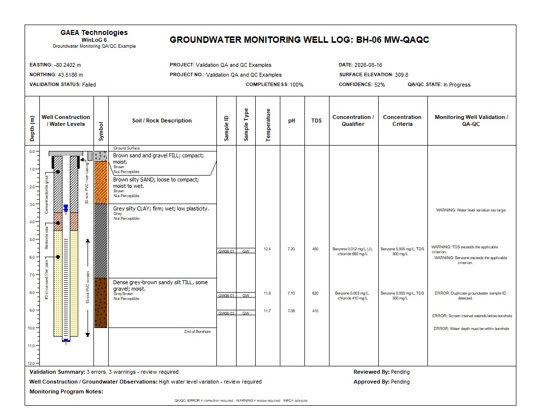
A focused groundwater validation example using BH-06 MW-QAQC. It combines monitoring-well construction, multiple water-level observations, groundwater samples, field parameters, laboratory results, and applicable criteria.
Demonstrates: component depth validation, water depth range checking, water-level variation, duplicate groundwater sample identifiers, temperature, pH, TDS and benzene criterion exceedances, laboratory qualifiers, and depth-linked validation reporting.
A focused mineral exploration validation example using ME-01 GOLD-QAQC. It combines geology and mineralization, core sampling and recovery, Au, Ag, Cu and As assays, alteration, veins, completeness, and cross-dataset geological QA/QC.
Demonstrates: recovery versus sample length, missing required assays, conflicting primary Au results, high-grade Au without a corresponding vein observation, logged mineralization without a required assay, and 96% assay completeness.
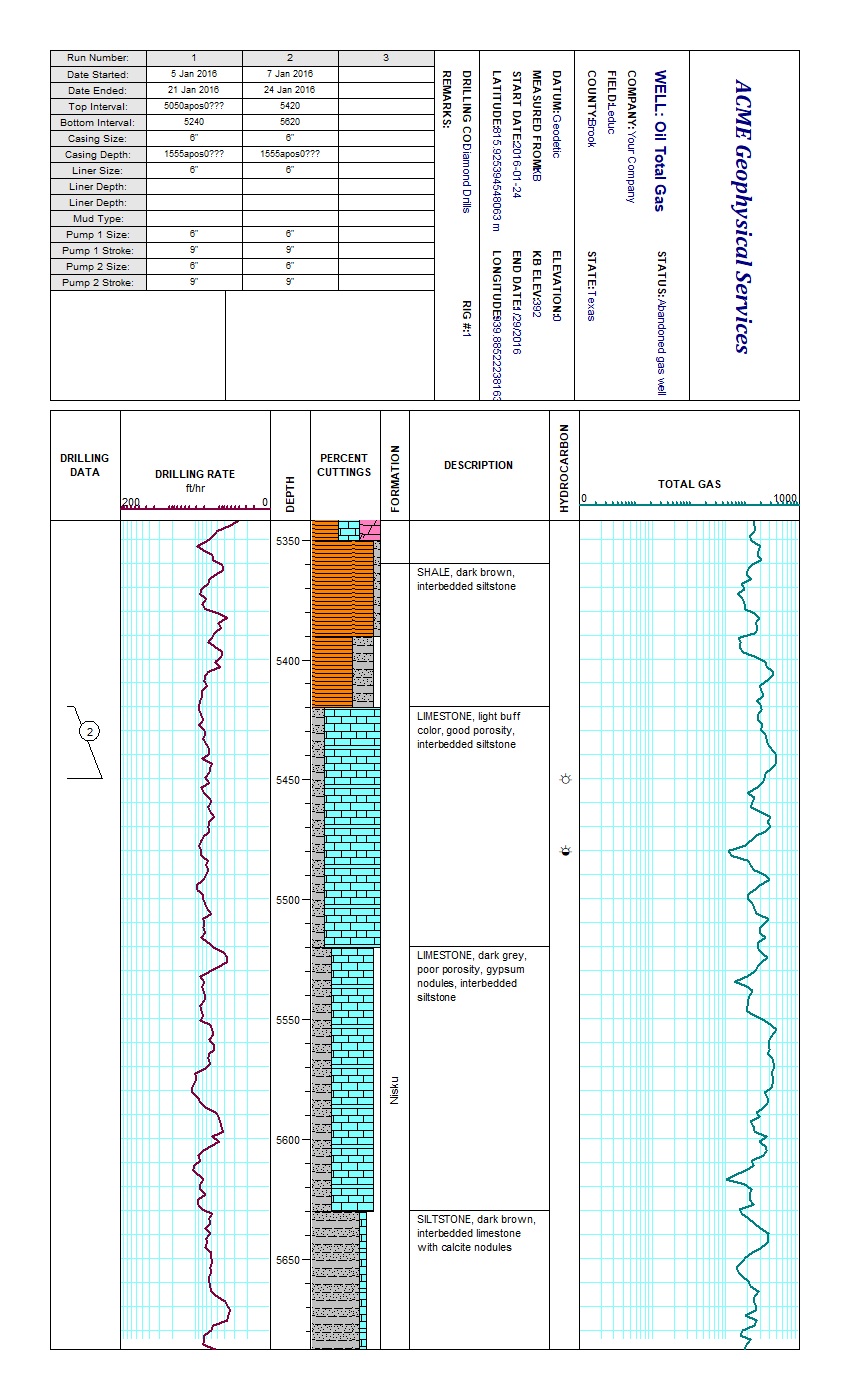
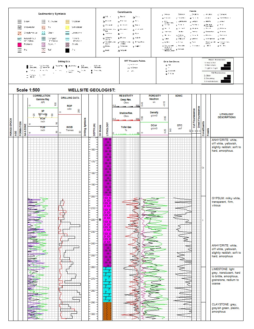
A focused oil and gas exploration validation example using OG-01 OIL-GAS-QAQC. It combines lithology, formation tops, total gas, methane, ROP, gamma ray, hydrocarbon shows, oil staining, drilling remarks, and cross-dataset QA/QC.
Demonstrates: formation-top boundary alignment, duplicate hydrocarbon-show detection, oil staining without a nearby show, a strong show without nearby staining, depth-linked findings, and 100% completeness.
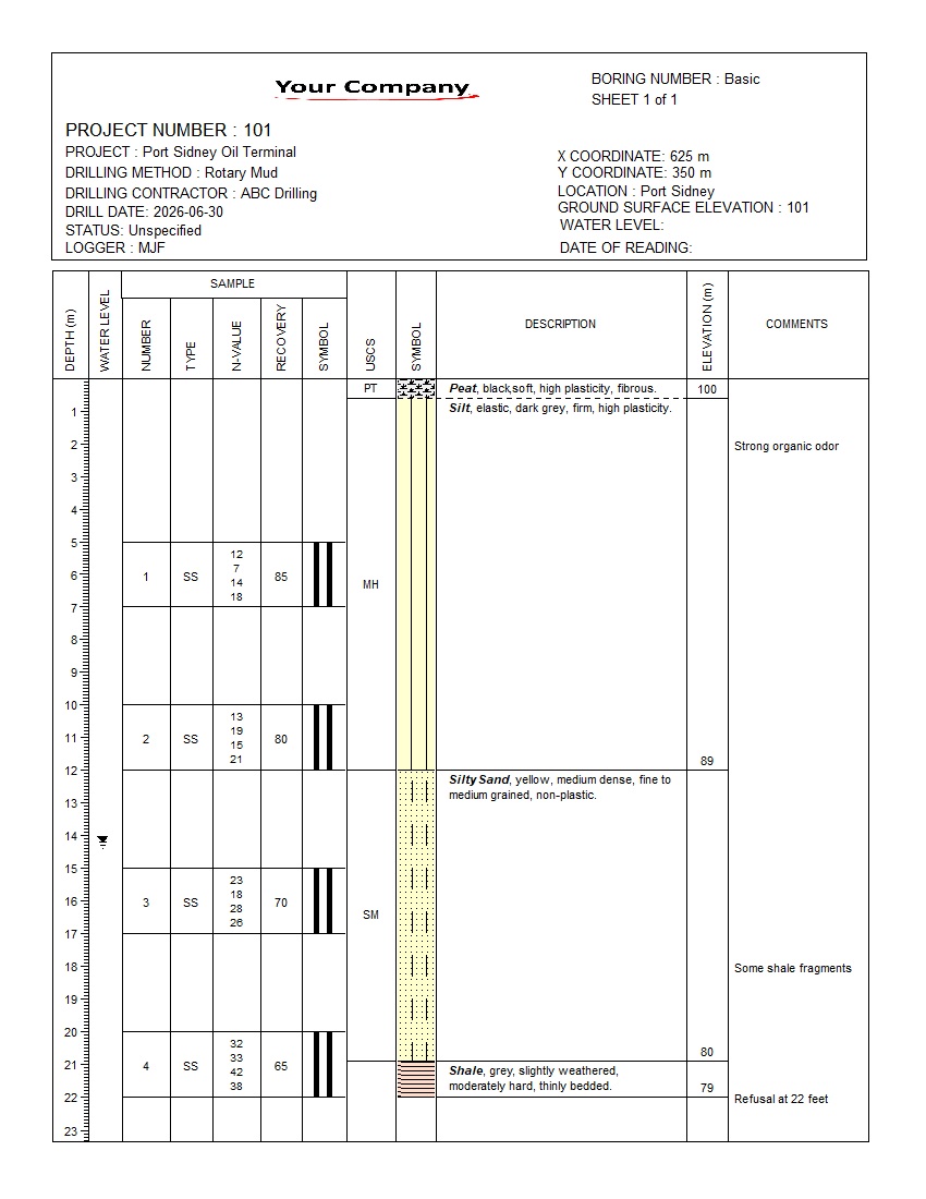
A clean, validated one-page boring log showing lithology, sample intervals, split-spoon samples, SPT blow counts, recovery, USCS classification, elevations, and field comments.
Highlights: Lithology, SPT, Recovery, USCS, Elevation, Passed Validation.
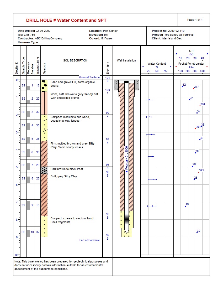
A validated one-page geotechnical log combining lithology, ten split-spoon samples, SPT N-values, recovery, water content, Atterberg Limits, pocket-penetrometer data, and well construction.
Highlights: SPT, Recovery, Water Content, Atterberg Limits, Strength, Well Installation.
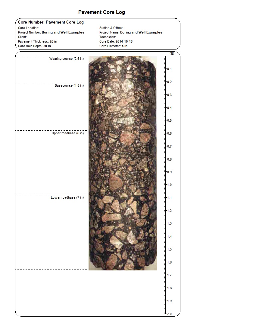
A validated one-page pavement record aligning a continuous core photograph with wearing course, basecourse, upper roadbase, and lower roadbase boundaries.
Highlights: Core Photograph, Pavement Layers, Thickness, Depth Scale, Transportation.
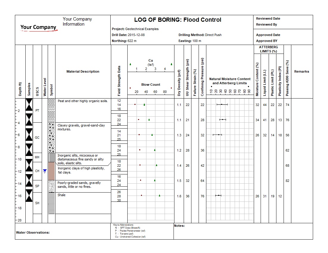
A validated direct-push boring log combining lithology, seven sample intervals, field strength, blow counts, dry density, UU shear strength, water content, Atterberg Limits, and grain-size data.
Highlights: Lithology, Field Strength, Blow Counts, UU Shear, Atterberg Limits, No. 200 Sieve.
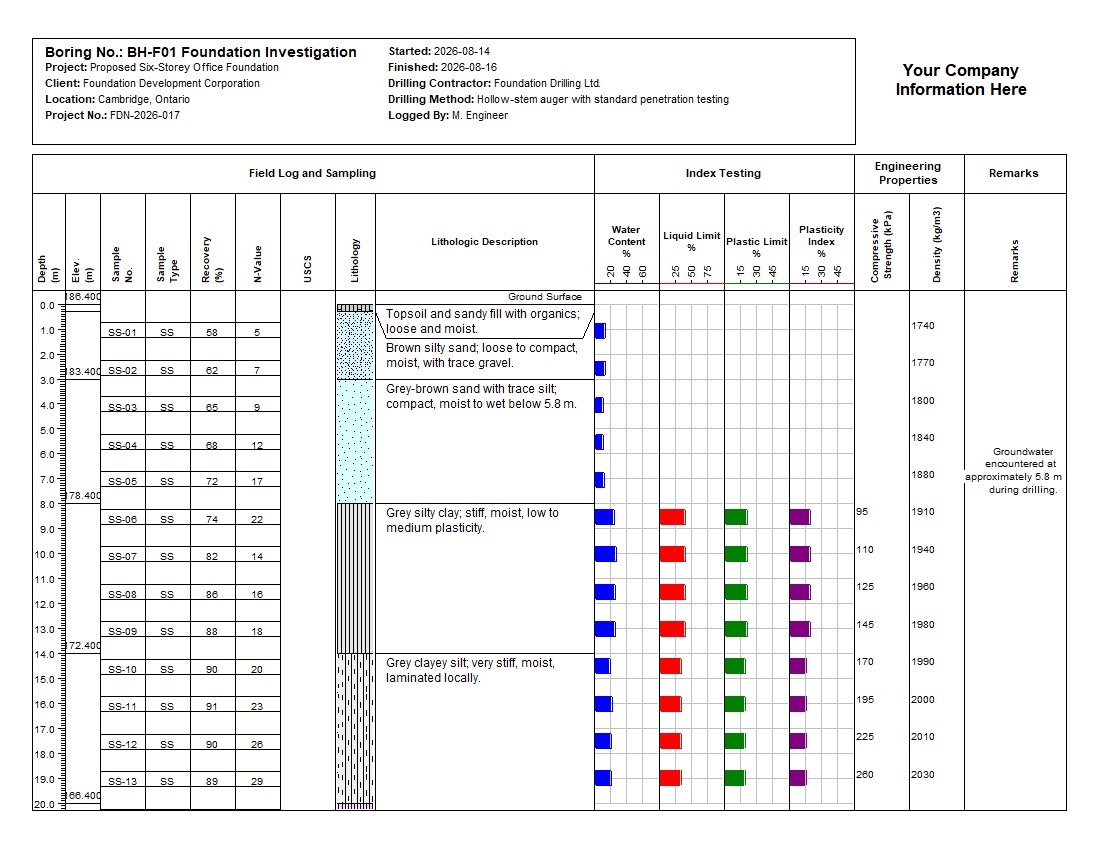
A complete 30 m foundation boring integrating lithology, twenty split-spoon samples, SPT N-values, recovery, water content, Atterberg Limits, compressive strength, density, and drilling observations.
Highlights: SPT, Recovery, Index Testing, Strength, Density, Two-Page Log.
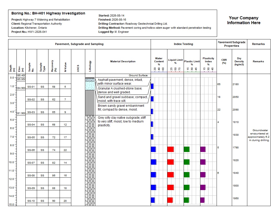
A complete 30 m roadway boring integrating pavement, base, subbase, fill, native subgrade, twenty split-spoon samples, SPT, groundwater, Atterberg Limits, CBR, dry density, and competent glacial till.
Highlights: Pavement, Subgrade, SPT, CBR, Dry Density, Two-Page Log.
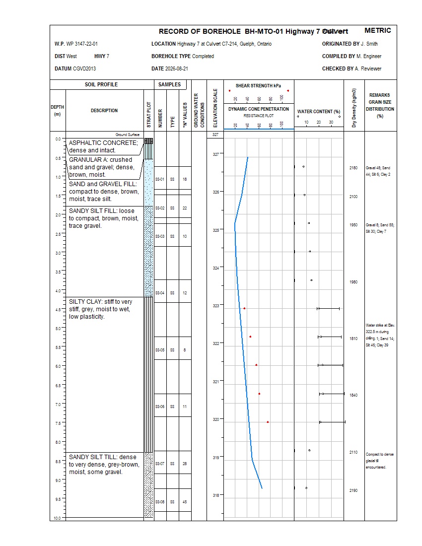
A complete 10 m MOT-style Highway 7 culvert borehole integrating pavement, fill, native soils, SPT, dynamic cone penetration, shear strength, water content, Atterberg Limits, dry density, and grain-size data.
Highlights: MOT Format, SPT, Cone Penetration, Shear Strength, Water Content, Dry Density, Single-Page Log.
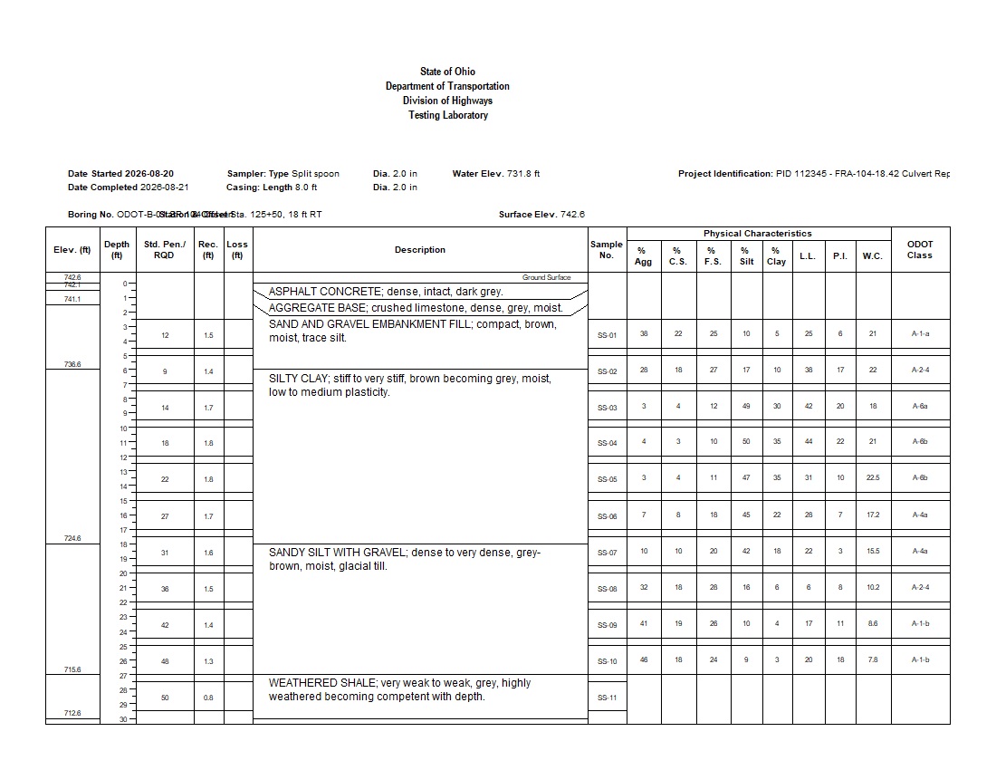
A complete 30 ft Ohio DOT-style SR 104 culvert borehole integrating pavement, fill, native soils, SPT, recovery, sample loss, water content, Atterberg Limits, five grain-size fractions, and ODOT classifications.
Highlights: Ohio DOT Format, SPT, Recovery, Loss, Water Content, Grain Size, ODOT Class, Single-Page Log.
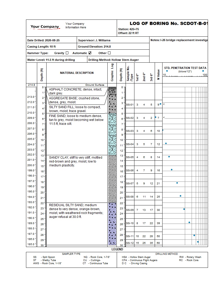
A complete 30 ft SCDOT-style I-26 bridge replacement boring integrating pavement, roadway fill, native and residual soils, twelve split-spoon samples, three blow-count increments, SPT N-values, groundwater, stationing, and elevations.
Highlights: SCDOT Format, Pavement, Lithology, SPT Blow Increments, N-Value Graph, Groundwater, Single-Page Log.
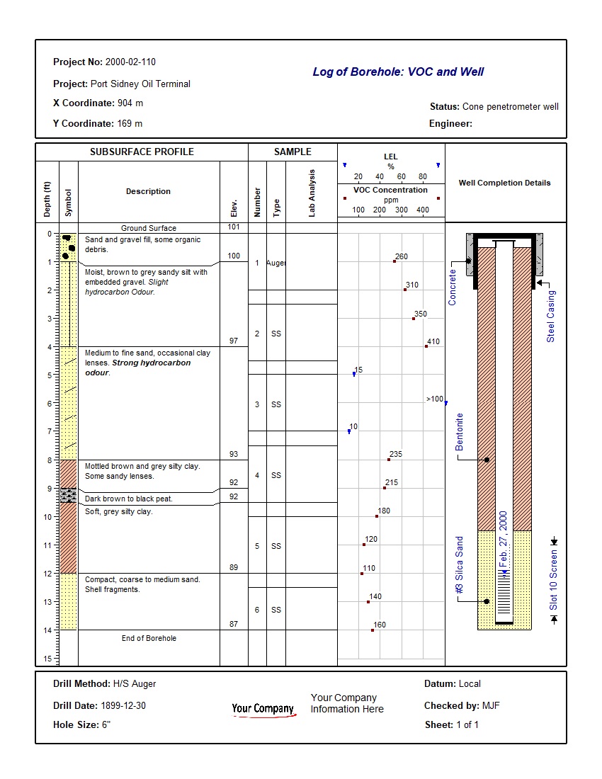
A validated one-page environmental log combining lithology, sampling, VOC concentrations, LEL readings, hydrocarbon-odour observations, groundwater, and detailed monitoring-well construction.
Highlights: VOC, LEL, Samples, Hydrocarbon Odour, Water Level, Well Completion.
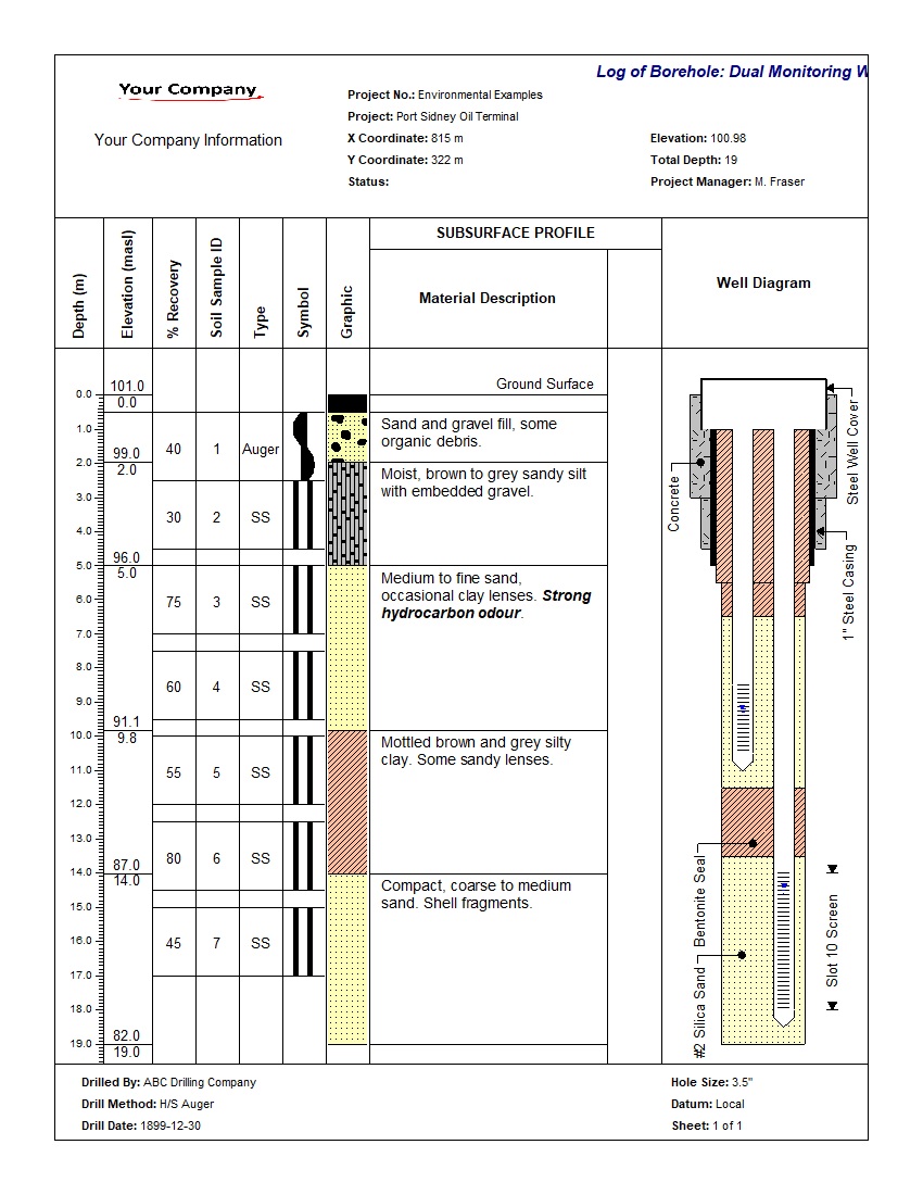
A dual-well environmental log showing separate shallow and deep screens, casing, filter packs, bentonite seals, groundwater levels, lithology, samples, and recovery.
Highlights: Dual Wells, Nested Screens, Water Levels, Well Construction, Samples, Validation Warning.
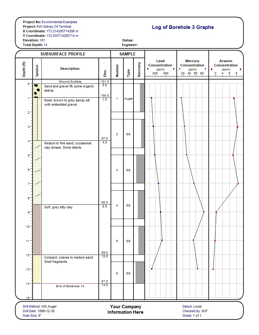
A validated environmental log plotting lead, mercury, and arsenic concentration profiles beside lithology, elevation, sample intervals, sample type, and recovery.
Highlights: Lead, Mercury, Arsenic, Concentration Profiles, Samples, Recovery.
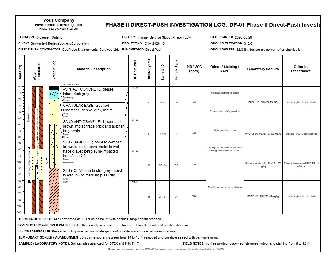
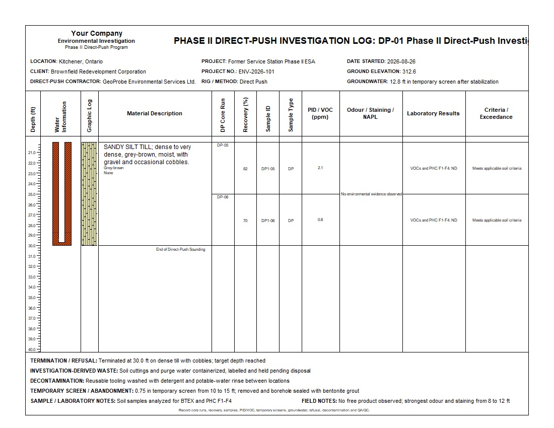
A complete 30 ft Phase II sounding combining six continuous core runs, recovery, discrete soil samples, PID/VOC screening, impact observations, laboratory results, criteria exceedances, temporary-screen groundwater sampling, decontamination, and abandonment records.
Highlights: Direct-Push Cores, Recovery, Samples, PID/VOC, BTEX and PHC Results, Temporary Screen, Groundwater.
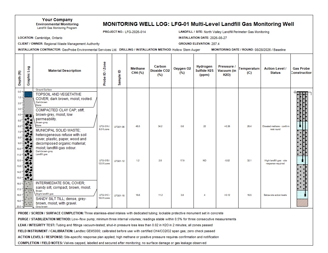
A complete 20 ft perimeter monitoring well with three isolated gas zones, graphical probe construction, depth-matched samples, landfill-gas composition, pressure, temperature, integrity testing, and site-specific response status.
Highlights: Three Gas Zones, CH4, CO2, O2, H2S, Pressure, Temperature, Probe Construction, Action Status.
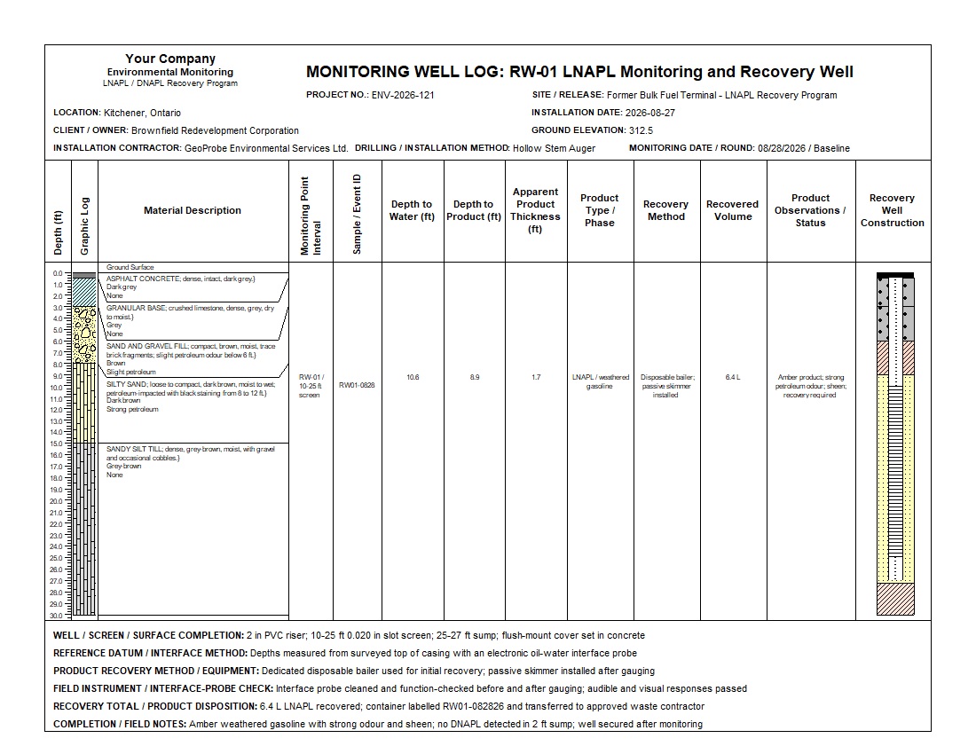
A complete 30 ft recovery well showing impacted stratigraphy, a 10-25 ft screen, water and product interfaces, 1.7 ft apparent LNAPL thickness, recovery method and volume, product observations, disposition, and field QA/QC.
Highlights: LNAPL Interfaces, Apparent Thickness, Recovery Volume, Passive Skimmer, Product Sump, Well Construction.

A complete 10 ft vibracore with five continuous runs, recovery and compression, sediment stratigraphy, five analytical sample sections, redox and field observations, laboratory results, criteria status, and continuous core photography.
Highlights: Vibracore Runs, Recovery, Compression, Sediment Samples, Metals, PAHs, PCBs, Redox, Core Photography.
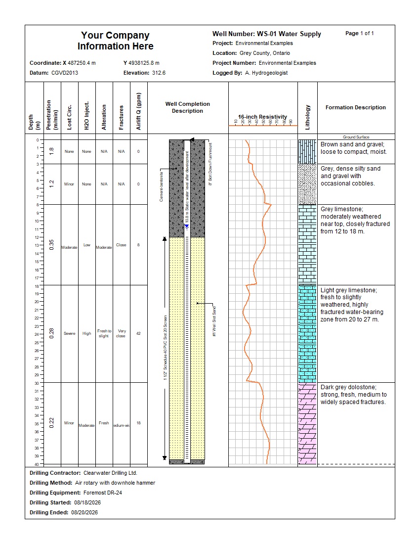
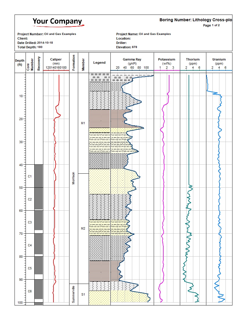
A hydrogeological well log combining lithology, penetration rate, lost circulation, water injection, fractures, airlift yield, well completion, and 16-inch resistivity sampled every 0.5 m.
Highlights: Well Construction, Resistivity, Airlift Yield, Water-Bearing Fractures, Lithology.
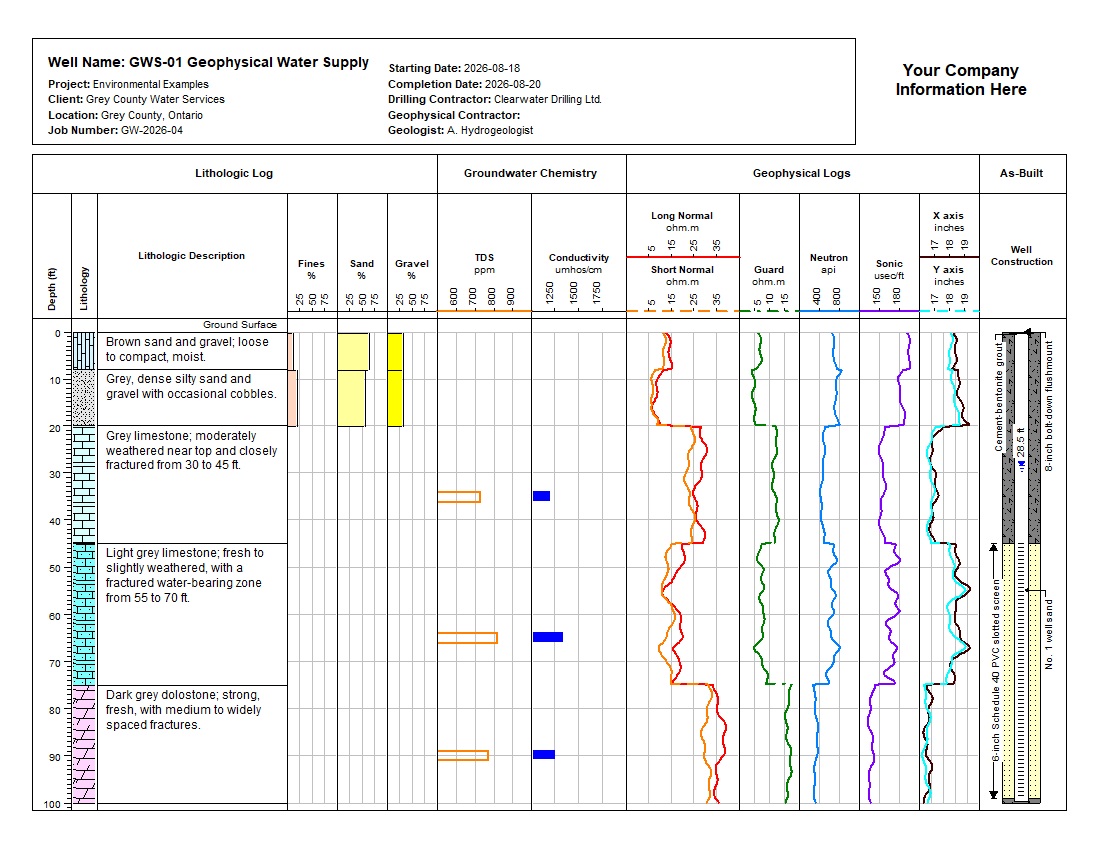
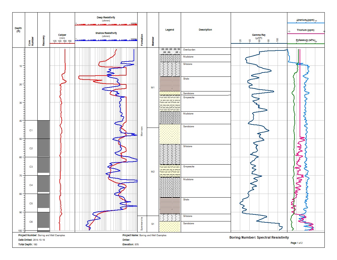
A validated water-supply log combining lithology, particle-size data, groundwater chemistry, seven geophysical curves sampled every 0.25 ft, dual-axis caliper, and as-built well construction.
Highlights: Long and Short Normal, Guard, Neutron, Sonic, Caliper X/Y, Chemistry, Well Construction.
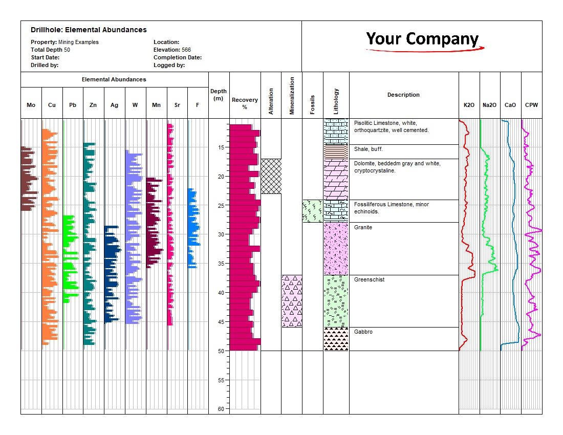
A validated mineral-exploration log combining nine elemental profiles, four geochemical and mineral curves, recovery, lithology, alteration, mineralization, fossils, and geological descriptions.
Highlights: Mo, Cu, Pb, Zn, Ag, W, Mn, Sr, F, K2O, Na2O, CaO, CPW, Recovery.

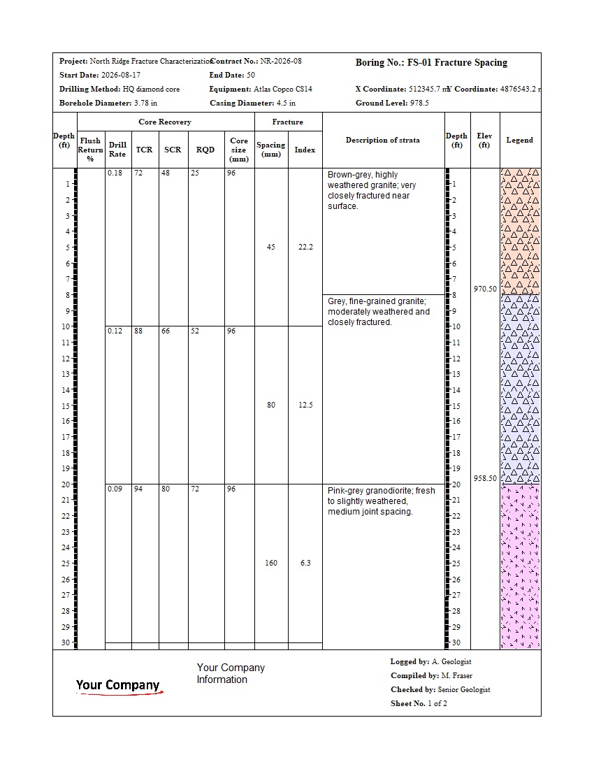
A validated two-sheet rock-core log combining lithology, instrumentation, weathering, hardness, point-load and uniaxial strength, discontinuity data, core recovery, and RQD.
Highlights: Lithology, Weathering, Rock Strength, Discontinuities, Core Recovery, RQD.
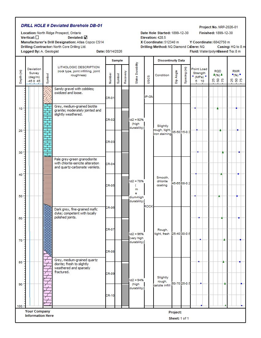
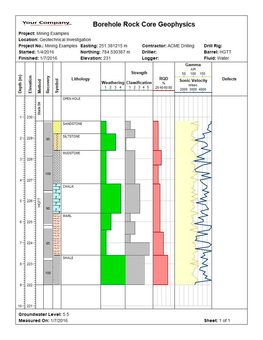
A validated mining borehole log combining a downhole deviation survey with lithology, core samples, recovery, slake durability, discontinuity data, point-load strength, RQD, and RMR.
Highlights: Deviation Survey, Lithology, Core Recovery, Discontinuities, Point Load, RQD, RMR.

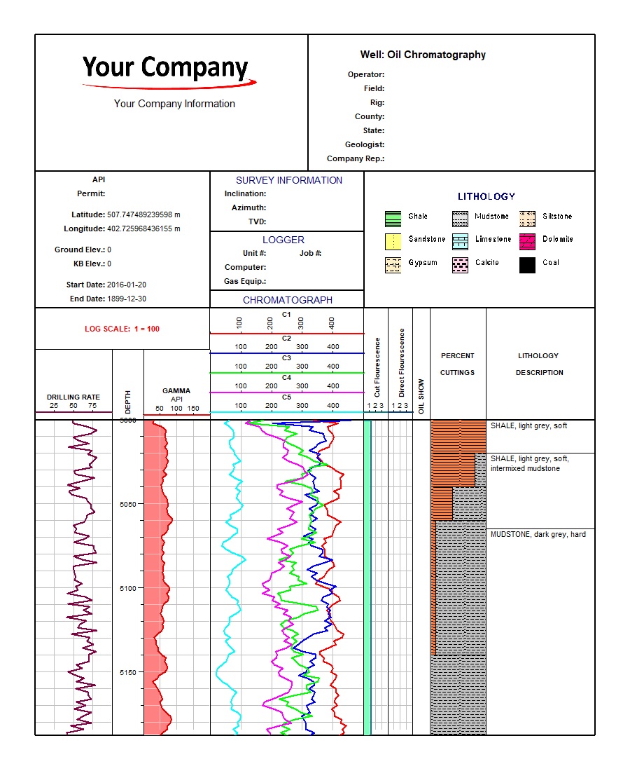
A detailed petroleum log combining proportional cuttings, lithology, formations, grain size, constituents, fossils, facies, oil staining, diagenesis, and porosity type.
Highlights: Percent Cuttings, Grain Size, Lithology, Formation Tops, Oil Staining.
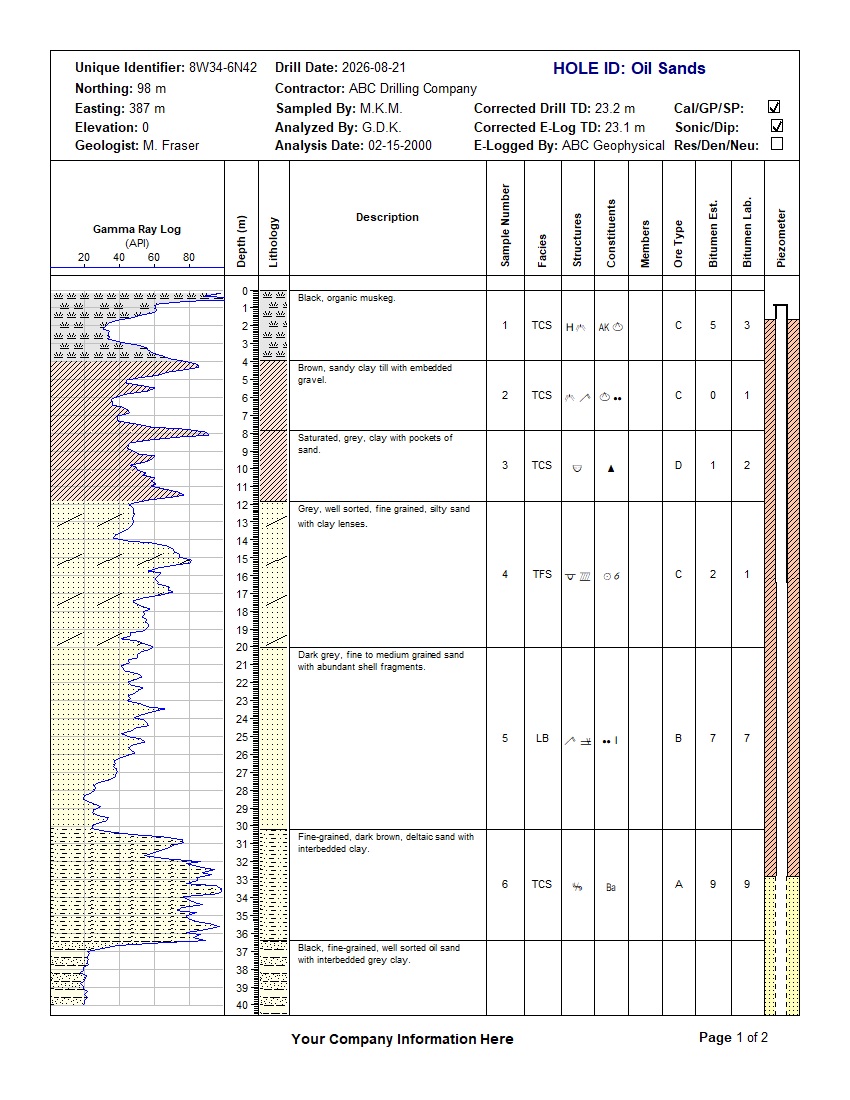
An oil-sands exploration log combining gamma ray, lithology, sample data, facies, structures, constituents, oil staining, bitumen estimates, laboratory results, and piezometer construction.
Highlights: Gamma Ray, Lithology, Facies, Oil Staining, Bitumen Results, Piezometer.
WinLoG templates can be configured for many specialized subsurface data-collection and reporting workflows.
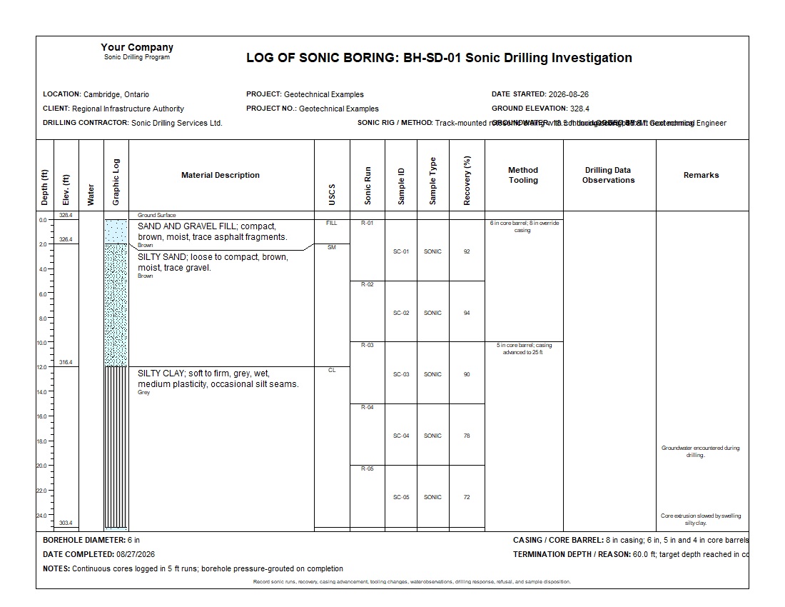
A complete 60 ft sonic boring with continuous five-foot runs, recovery, USCS classifications, groundwater, tooling changes, casing advancement, drilling observations, and weathered shale termination.
Highlights: Continuous Sonic Core, 12 Runs, Recovery, USCS, Tooling, Groundwater, Drilling Observations.
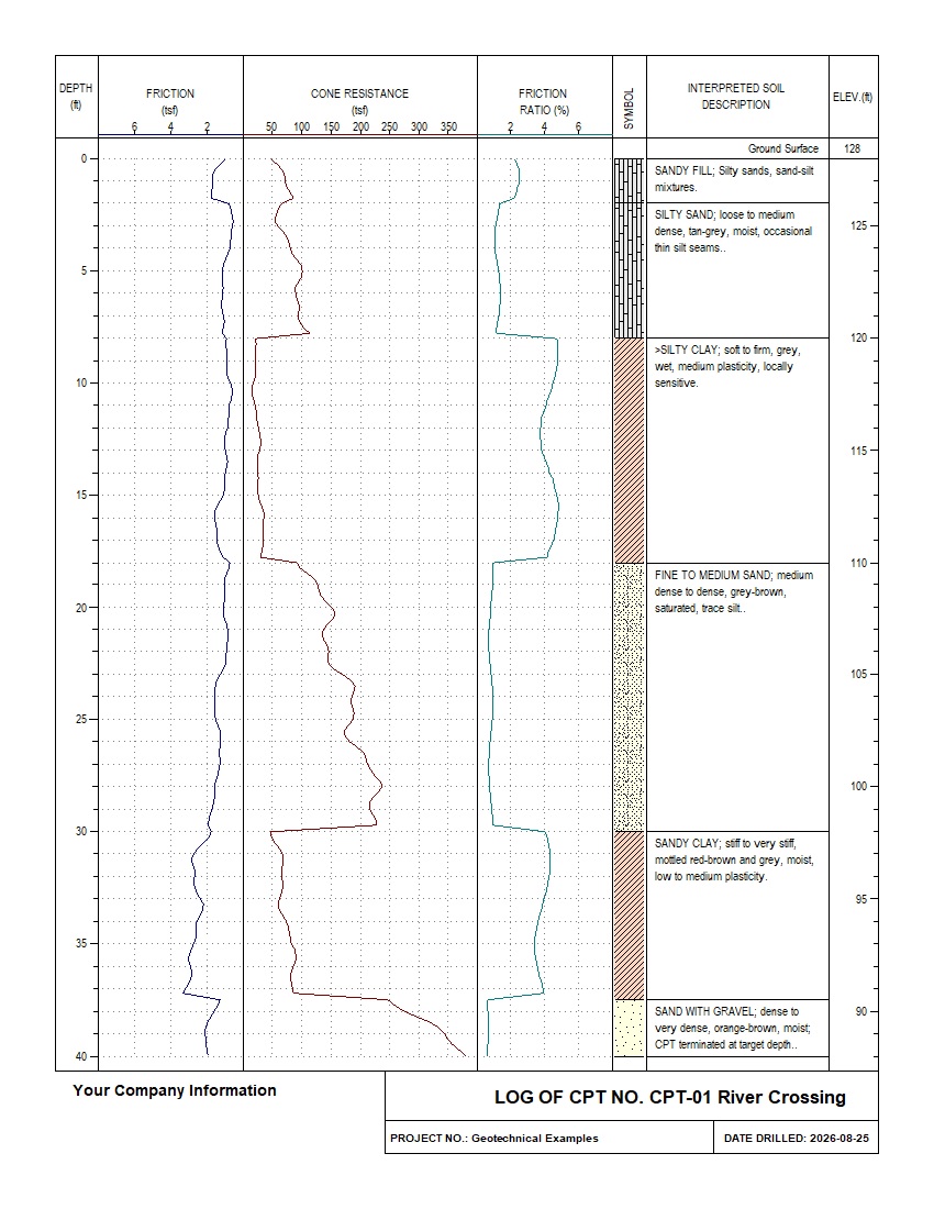
A complete 40 ft cone penetration test sounding with continuous cone resistance, sleeve friction, friction ratio, and six interpreted soil intervals.
Highlights: Cone Resistance, Sleeve Friction, Friction Ratio, Interpreted Stratigraphy, Single-Page Log.
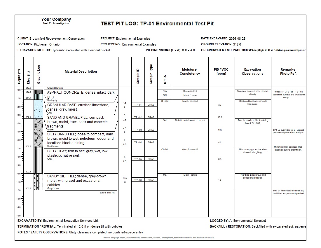
A complete 12 ft environmental test-pit log with pavement, fill, native soils, grab samples, USCS classifications, PID/VOC screening, seepage, excavation observations, photographs, and restoration details.
Highlights: Shallow Excavation, Grab Samples, USCS, PID/VOC, Impacted Soil, Seepage, Photo References.
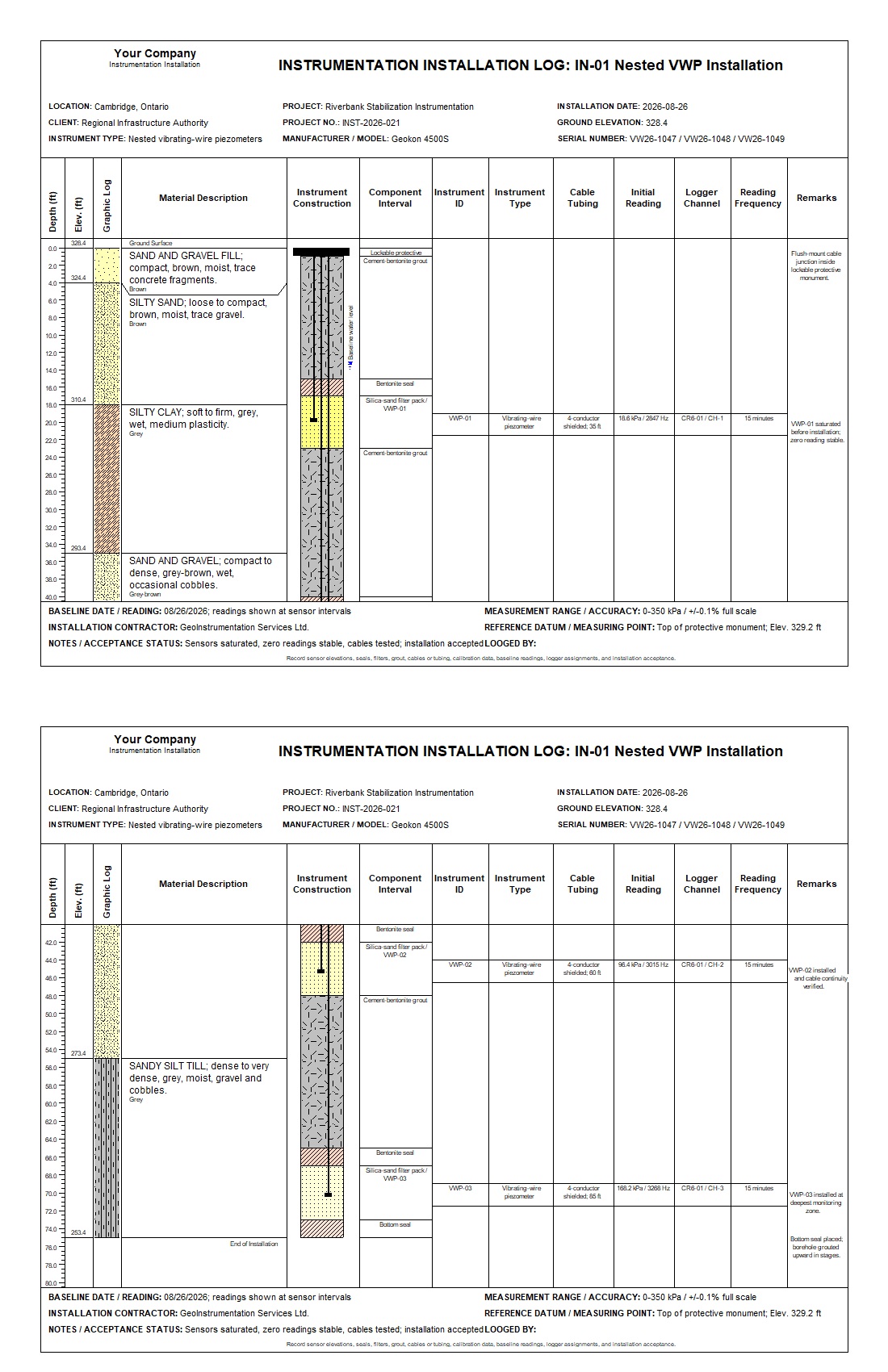
A complete 75 ft nested vibrating-wire piezometer installation log with subsurface conditions, graphical construction, isolated filter zones, cables, baseline readings, logger channels, monitoring frequency, and acceptance notes.
Highlights: 3 VWP Sensors, Sand Filter Packs, Bentonite Seals, Grout, Shielded Cables, Baseline Readings, Datalogger Channels.
WinLoG XML templates can be customized to match company standards, project requirements, and agency formats.
Download example XML templates and logs, import them into WinLoG, and adapt them for your own projects.
Contact GAEA Technologies for assistance selecting or customizing a WinLoG template.

GAEA Technologies develops and distributes geoscience and engineering solutions worldwide. Our solutions have been used for over 30 years by companies and organizations around the world.
© 2026 - All Rights Reserved/span>